Land surveying is a critical practice in the development of any land-based project. It serves as the foundation for site planning, design, and construction. Among the numerous types of surveys and plans that form part of this process, the contour plan holds a special place. It provides a two-dimensional representation of the terrain, crucial for architects, engineers, and contractors. This guide delves into the intricacies of contour plans and their relevance in land surveying.
What Is a Contour Plan?
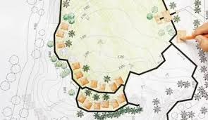
A contour plan is a detailed map that illustrates the topography of the land. It comprises numerous contour lines that trace levels of equal elevation. Thus, they effectively convey the rises and dips of the terrain, allowing professionals to comprehend the characteristics of the landscape without having physically visited the site.
The Importance of Accurate Contour Plans
To ensure the success of construction and design projects, an accurate contour plan is indispensable. It influences key decisions about drainage patterns, soil preservation, and foundational support – all factors that affect the lasting stability of a structure. Without a reliable contour map, projects are susceptible to costly mistakes and potential failures.
Understanding the Basics of Contour Lines
Contour lines are the heart of any contour map. These lines connect points of equal altitude, representing the terrain’s shape. Close-knit lines suggest a steep slope, while distantly spaced lines suggest a gentler incline. Learning to read these lines is essential for any stakeholder involved in land development.
Construction Planning and Contour Maps
When it comes to the practical applications of contour plans, construction planning is at the forefront. These plans help in identifying the most suitable building sites, determining where and how to adjust the earth for stability, and even in creating pathways for utilities that must traverse various elevations.
Environmental Considerations and Contour Plans
Aside from construction, environmental considerations play a significant role in the utility of contour plans. They provide data crucial for managing water run-off, maintaining the natural topography, and reducing erosion. They help in planning how a project integrates with the natural landscape, aiming for sustainability and reduced environmental impact.
Making Use of Contour Plans
For architects, a contour plan serves as an essential canvas on which they will craft their designs. It influences the aesthetics and practicality of their structures. Meanwhile, engineers use these maps to calculate earthwork volumes, design roads, and manage utility routes. Contractors rely on them for accurate estimations and to avoid unexpected terrain-related complexities during construction.
read more : Maximizing Off-Road Performance: The Role of Sway Bar Links
Technology and Contour Plans
Advancements in technology have transformed the field of surveying, and by extension, the creation of contour plans. Modern equipment such as drones, laser scanning, and geographic information systems (GIS) have vastly improved the accuracy and speed of mapping terrain. This technological evolution benefits all aspects of land development and engineering.
Commissioning a Contour Plan
When the need for a contour plan arises, it is paramount to commission a survey from a reputable firm. Professional land surveyors, equipped with the latest technology and a deep understanding of local geographies, can deliver precise and reliable plans. Their expertise is invaluable in navigating any potential legal and environmental complications as well.
Reading and Interpreting Contour Plans
A well-executed contour plan is only as useful as one’s ability to interpret it. Learning to read the variances in line spacing, recognizing the indications of natural and man-made features, and understanding the standard notation and symbols are all key skills. Mastery in these areas ensures better communication and fewer errors in all stages of land development.
Challenges in Land Surveying and Contour Mapping
Despite advancements in technology, land surveying and contour mapping present challenges. Difficult terrain, large-scale projects, and changing environmental conditions can all complicate the surveying process. Skilled surveyors must navigate these with expertise and adaptability to produce accurate contour plans.
The Future of Contour Plans in Development
As urbanization and development continue to advance, the need for detailed and precise contour plans will only grow. These plans will play an increasingly important role in the efficient and sustainable development of land, facing the dual demands of progress and environmental stewardship.
Conclusion
In conclusion, a contour plan is an indispensable tool in land surveying and development. It provides a versatile and intricate representation of the terrain, informing decisions that have long-term implications for any project. Whether you are an architect, an engineer, a contractor, or an environmental consultant, understanding and making use of high-quality contour plans is crucial to success. With technology advancing and the stakes only getting higher, the reliance on accurate and detailed contour plans will continue to be an essential facet of land development.